The Diamond Loop Tour Route
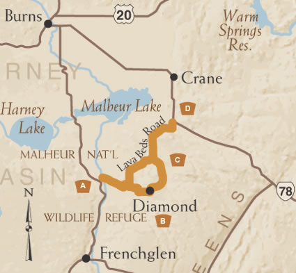
Winding through a variety of high desert habitats, the Diamond Loop Tour Route offers wildlife watching, the historic Round Barn and the fascinating geologic formations of the Diamond Craters. It provides views of the high desert, from mountains to the sage covered hills. The route offers opportunities to view wild life, historic ranches of the Diamond Valley, the Round Barn, along with the geologic formations of the Diamond Craters.
A. Along the Marsh
You'll begin on the Diamond Loop Tour Route by heading east on South Diamond Lane, through the southern section of the Malheur National Wildlife Refuge. An important stopping point along the Pacific Flyway, the refuge offers a wonderful opportunity for viewing of a variety of bird species from waterfowl, and shorebirds, to hawks and eagles. Mule deer and antelope also make their home here.
B. Diamond in the Rough
Diamond is a small ranching community that takes its name from rancher Mace McCoy's diamond brand. It was established as a major supply center for ranchers, sheepherders, and travelers. Today, the town of Diamond has the recently renovated Hotel Diamond, a store and a few residences. East of Diamond, an eleven mile dirt road leads to the Kiger Mustangs Viewing Area. These distinctive wild horses are believed to closely resemble the horses brought to North America by the Spaniards in the late 16th century. (Recommended for 4-wheel drive, high clearance vehicles and dry weather travel only.)
C. Historic Round Barn
Continuing north, you'll reach the Peter French Round Barn, built in the late 1870's or early 1880's by its namesake. The barn is 100 feet in diameter featuring a 60-foot round stone corral surrounded by a 20-foot wide outer circle paddock with an umbrella-type center truss and centrally supported rafters. Its unusual design was perfectly suited for its purpose: breaking horses during long eastern Oregon winters. A recently constructed Visitor Center at the site offers exhibits and souvenirs.
D. Diamond Craters
Driving west on Lava Beds Road, you'll soon come to Diamond Craters Outstanding Natural Area, home to some of Americans most diverse basaltic volcanic formations. The craters were formed when molten basalt spilled from fissures in the earth and flooded in a thin layer over a dry lake bed. Before the initial layer cooled completely, more basaltic magma injected underneath, creating six arching structural domes. A self-guided tour highlights Lava Pit Crater, Graben Dome and other noteworthy features of the site.