The Blue Mountains Scenic Byway
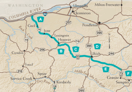
Back through pioneer history. Up through incredible scenery. An alternative to I-84 for east-west travelers between Arlington and Baker City. Charming towns dot the route, and outdoor recreational opportunities abound along the eastern leg.
A. The Lowlands
Set out from the Byway's western portal at Heppner Junction off I-84 between Arlington and Hermiston and prepare for a history lesson. Willow Creek, near the town of Cecil, was a popular stopping place along the Oregon Trail.
Oregon Route 74 continues southeast along the creek, through bountiful wheat and canola fields and ranches, to the agricultural communities of Ione and Lexington. These towns, which began as sheep stations, still maintain classic examples of frontier architecture.
B. Heppner
Nine miles beyond Lexington, Heppner is a commercial and recreational gateway to the Blue Mountains. Visit the Morrow County Museum, which hosts one of the finest collections of artifacts of pioneer, homestead, and rural history in the Northwest; it also chronicles the great flood of 1903. A historic walking tour features a number of turn-of-the-century buildings, including the blue-stone courthouse. Willow Creek Lake offers boating and fishing a mile from downtown.
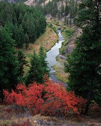
C. Into the Woods
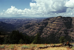 From Heppner, the Byway follows Willow Creek Road, then Forest Service
Road 53 as it climbs into the Umatilla National Forest. This 1.4 million-acre
expanse of pine and fir trees offers plenty of terrain for hikers and
horseback riders to explore. As you travel, notice how the forest is recovering
from a wildfire and an insect epidemic. You'll pass Cutsforth Park, a
popular camping and picnic spot, and the Coalmine Hill day-use area provides
access to several hiking and horseback trails. Farther along the Byway,
Potamus Point provides a panoramic view of the "Wild and Scenic"
North Fork John Day River. In the winter, herds of deer and elk can sometimes
be spotted.
From Heppner, the Byway follows Willow Creek Road, then Forest Service
Road 53 as it climbs into the Umatilla National Forest. This 1.4 million-acre
expanse of pine and fir trees offers plenty of terrain for hikers and
horseback riders to explore. As you travel, notice how the forest is recovering
from a wildfire and an insect epidemic. You'll pass Cutsforth Park, a
popular camping and picnic spot, and the Coalmine Hill day-use area provides
access to several hiking and horseback trails. Farther along the Byway,
Potamus Point provides a panoramic view of the "Wild and Scenic"
North Fork John Day River. In the winter, herds of deer and elk can sometimes
be spotted.
D. On the Ukiah
The Byway emerges from the forest and descends into an ancient lake basin that - according to Indian legend - was permanently emptied by a "great rumbling" that happened "many moons ago." The basin is the site of the small town of Ukiah. Bright blue camas flowers abound in the spring; native people relied on the camas root as a food source.
E. Back into the Woods
After crossing U.S. Route 395 and the Camas River, the Byway continues southeast on Forest Service Road 53, climbing quickly into the forest again. Soon, you'll reach the Bridge Creek Wildlife Area, which serves as a wintering ground for one of the largest herds of Rocky Mountain elk in the nation. A short trail provides a good vantage point of the wintering grounds; the best time to see elk is from December through May. About nine miles east, the North Fork John Day Overlook presents a spectacular view of the John Day Wilderness to the north and the Strawberry Mountain Wilderness Area to the south. You may be able to spot elk at Bridge Creek Flats. There are an abundance of campgrounds and hiking trails along the North Fork John Day and Camas rivers. Anglers focus on these waters for rainbow trout and steelhead.
F. End on the John Day
The Byway's east portal is located at the North Fork John Day Campground, another popular fishing spot. From here, the Byway overlaps with the Elkhorn Drive Scenic Byway; if you're heading farther east, it's a relaxing alternative to I-84. Take Forest Service Road 73 east through Anthony Lakes to Haines, or south through the mining towns of Granite and Sumpter toward Baker City. You may also return to I-84 by heading north on Forest Service Road 51 and following the Grande Ronde River to La Grande.