The McKenzie Pass—Santiam Pass Scenic Byway
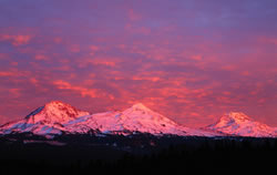
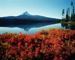
Lava fields, snowcapped peaks and rushing rivers mark this 82-mile loop around two of central Oregon's Cascade Mountain passes. Anglers, hikers and skiers will delight in the ample recreational opportunities this Byway provides, and everyone will appreciate the striking alpine scenery.
 The
McKenzie Pass-Santiam Pass Scenic Byway takes you on a journey through
a land of contrasts. On the west side of the Cascades, you'll encounter
lush Douglas fir and red cedar forests; on the drier east side, lodgepole
pines prevail. Lava fields adjoin snow fields, providing a stark black
and white contrast between the forces of fire and ice, a contrast that's
often mirrored in crystal-clear lakes, whose still waters are countered
by several cascading waterfalls. The Byway boasts the highest concentration
of snowcapped volcanoes (and associated glaciers) in the lower 48 states.
Broken Top Mountain, Mount Washington and The Three Sisters (among other
peaks) tower above the Byway.
The
McKenzie Pass-Santiam Pass Scenic Byway takes you on a journey through
a land of contrasts. On the west side of the Cascades, you'll encounter
lush Douglas fir and red cedar forests; on the drier east side, lodgepole
pines prevail. Lava fields adjoin snow fields, providing a stark black
and white contrast between the forces of fire and ice, a contrast that's
often mirrored in crystal-clear lakes, whose still waters are countered
by several cascading waterfalls. The Byway boasts the highest concentration
of snowcapped volcanoes (and associated glaciers) in the lower 48 states.
Broken Top Mountain, Mount Washington and The Three Sisters (among other
peaks) tower above the Byway.
The natural qualities of the McKenzie Pass-Santiam Pass Scenic Byway are of national significance. There are outstanding examples of both ancient and recent volcanoes, cinder cones, lava flows, and deep, glaciated canyons. Forests along the Byway contain rare old-growth fir and ponderosa pine, and are home to a great variety of fish and wildlife, including several endangered species, such as bald eagles, northern spotted owls, Chinook salmon and bull trout.
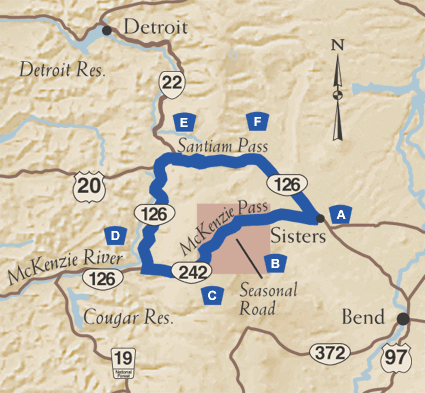
A. Start in Sisters
 While accessible from cities west of the Cascades, you'll enjoy this
Byway best by beginning at its eastern most point in Sisters, in the shadows
of the nearby Three Sisters peaks, Faith, Hope, and Charity. A quaint
town with western ambiance and a thriving arts scene that includes antique
stores, galleries and western boutiques, Sisters is a popular vacation
spot. Seasonal events include a popular rodeo, an outdoor quilt show and
a folk music festival. Rustle up a picnic lunch at a local bakery or supermarket,
fill your tank, and head west on Oregon Route 242 past llama ranches and
into the Deschutes National Forest.
While accessible from cities west of the Cascades, you'll enjoy this
Byway best by beginning at its eastern most point in Sisters, in the shadows
of the nearby Three Sisters peaks, Faith, Hope, and Charity. A quaint
town with western ambiance and a thriving arts scene that includes antique
stores, galleries and western boutiques, Sisters is a popular vacation
spot. Seasonal events include a popular rodeo, an outdoor quilt show and
a folk music festival. Rustle up a picnic lunch at a local bakery or supermarket,
fill your tank, and head west on Oregon Route 242 past llama ranches and
into the Deschutes National Forest.
B. McKenzie Pass
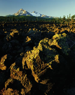
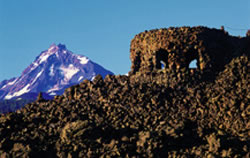
The Byway follows the path of an 1860s wagon route, emerging from the forest at Windy Point to a jaw-dropping vista of Mount Washington and a 65-square-mile lava flow. When you reach 5,325-foot McKenzie Pass, you're enveloped by lava on all sides. Take a few minutes to climb up to the Dee Wright Observatory, a lava rock structure constructed by the Civilian Conservation Corps in 1935, and named for their foreman. From the observatory, you can take in six Cascade peaks on a clear day. The half-mile Lava River Interpretive Trail is a 30-minute walk on a paved surface through lava gutters and crevasses. You are on the boundary here of two wilderness areas: Mt. Washington to the north and Three Sisters to the south.
C. Drop Into The Willamette National Forest
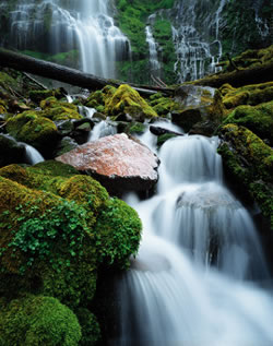
Descending from McKenzie Pass to the Willamette National Forest, you'll be treated to more outstanding mountain views, this time North and Middle Sister. A short side-trip takes you to Scott Lake, which mirrors these stately peaks. Nine miles west of the summit, Deadhorse Grade drops nearly 1,200 feet in less than four miles. Several hairpin turns later, look for the Proxy Falls Trailhead. These frequently photographed, ethereal falls, are well worth the short hike within the Three Sisters wilderness.
D. Up The McKenzie
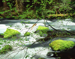
 As you turn onto Highway 126, you'll catch glimpses of whitewater boating
on the McKenzie River. Pull out at the newly constructed Wild and Scenic
River Viewpoint for a stroll through giant trees to a viewpoint perched
on the edge of frothing currents. Look for harlequin ducks loafing on
river rock islands. A few miles up the highway turns into Koosah Falls.
Here, a loop trail connects hikers to stunning Sahalie Falls and Carmen
Reservoir. As you ascend to stark lava fields that blocked Clear Lake,
pull into the Fish Lake Remount Depot for a step back into early Forest
Service and Civilian Conservation Crop history. A pioneer woman's gravesite
marks the treacherous journey early travelers made on the historic Santiam
Wagon Road.
As you turn onto Highway 126, you'll catch glimpses of whitewater boating
on the McKenzie River. Pull out at the newly constructed Wild and Scenic
River Viewpoint for a stroll through giant trees to a viewpoint perched
on the edge of frothing currents. Look for harlequin ducks loafing on
river rock islands. A few miles up the highway turns into Koosah Falls.
Here, a loop trail connects hikers to stunning Sahalie Falls and Carmen
Reservoir. As you ascend to stark lava fields that blocked Clear Lake,
pull into the Fish Lake Remount Depot for a step back into early Forest
Service and Civilian Conservation Crop history. A pioneer woman's gravesite
marks the treacherous journey early travelers made on the historic Santiam
Wagon Road.
E. Ascend to Santiam
 A few miles north of Clear Lake, Oregon Route 126 joins U.S. Route 20
and Oregon Route 22, and turns east toward the Santiam Pass and Sisters.
The pass was discovered in 1859 by Andrew Wiley and was named for the
Santiam Indians, a Kalapooian tribe living near the Santiam River. The
Byway crosses the route of the Willamette Valley Cascade Mountain Wagon
Road, later known as the Santiam Wagon Road, still used today as a secondary
road for public access. A portion of the original railroad grade of the
Hogg Railroad, constructed in the late 1800s, is visible from Santiam
Pass near Hogg Rock. As you climb to Santiam Pass, you'll see a side road
for Hoodoo Ski Area which features downhill and cross-country skiing from
December to March. Big Lake, a popular recreation area with a dramatic
view of Mount Washington, can also be accessed from this road. Shortly
beyond the Hoodoo turnoff the Byway crosses the Pacific Crest Trail and
4,817-foot Santiam Pass. This section of the Pacific Crest Trail provides
backpackers with a unique opportunity to hike the crest of a major volcanic
mountain range.
A few miles north of Clear Lake, Oregon Route 126 joins U.S. Route 20
and Oregon Route 22, and turns east toward the Santiam Pass and Sisters.
The pass was discovered in 1859 by Andrew Wiley and was named for the
Santiam Indians, a Kalapooian tribe living near the Santiam River. The
Byway crosses the route of the Willamette Valley Cascade Mountain Wagon
Road, later known as the Santiam Wagon Road, still used today as a secondary
road for public access. A portion of the original railroad grade of the
Hogg Railroad, constructed in the late 1800s, is visible from Santiam
Pass near Hogg Rock. As you climb to Santiam Pass, you'll see a side road
for Hoodoo Ski Area which features downhill and cross-country skiing from
December to March. Big Lake, a popular recreation area with a dramatic
view of Mount Washington, can also be accessed from this road. Shortly
beyond the Hoodoo turnoff the Byway crosses the Pacific Crest Trail and
4,817-foot Santiam Pass. This section of the Pacific Crest Trail provides
backpackers with a unique opportunity to hike the crest of a major volcanic
mountain range.
F. Slide Back To Sisters
 A combination of world-class rivers, pristine alpine lakes, sensational
scenery and a dry climate make Central Oregon a recreational paradise.
Indeed, there are several months of the year when you can ski in the morning
at higher elevations, then hike, fly-fish, bicycle, golf or play tennis
in the afternoon at lower elevations along the Byway!
A combination of world-class rivers, pristine alpine lakes, sensational
scenery and a dry climate make Central Oregon a recreational paradise.
Indeed, there are several months of the year when you can ski in the morning
at higher elevations, then hike, fly-fish, bicycle, golf or play tennis
in the afternoon at lower elevations along the Byway!
Just east of Santiam Pass, Suttle Lake welcomes boaters, windsurfers and fishermen. Further east, take a side road to Camp Sherman, and see where the Metolius River bubbles up from underground springs near the base of Black Butte. With Mount Jefferson looming in the background, it's a scene of unforgettable beauty. The Metolius draws fly fishing aficionados from around the world to ply its gin clear waters for wary native redband trout. Comfortable streamside accommodations are available at Camp Sherman. On the home stretch to Sisters, the 6,436-foot cone of Black Butte rises abruptly on the left. A rather rigorous hike to the summit of Black Butte offers views that seem to go on forever.
A Land of Fire and Ice
The McKenzie-Santiam Pass Scenic Byway features geologically noteworthy volcanic and glacial landscapes. The region illustrates how the great bulk of the volcanic Cascade Range has been built. Here, basaltic shield volcanoes are produced on a regular basis. Shields, the building blocks of the Cascades, are low broad cones of basalt lava, and resemble giant warrior's shields lying on the ground. Some have grown into large, steep-sided volcanic cones such as North Sister and Mt. Washington. Glaciers have deeply eroded most of these cones, but newer shields, unaffected by glaciers, are also present. Belknap Crater (which can be viewed from the Dee Wright Observatory) is an excellent example of a young shield, with its long, barren, gentle slopes of lava.
The contrast between older glaciated landscapes and newer unaffected volcanoes is striking. During the last Ice Age, some volcanoes erupted under and through glaciers, leaving formations such as flat-topped Hayrick Butte. Others were greatly eroded by glaciers, such as Mt. Washington, and their remains were spread over the land in large sheets of sand and gravel. Even today, a dozen glaciers grind away at the Three Sisters.
Five million years ago, a different skyline of volcanoes made up the Cascade crest. Then, accompanied by great earthquakes, the crest sank out of sight. For the past two million years, thousands of new volcanoes have erupted and rebuilt the crest. Will these volcanoes erupt again in the near future? It's possible. Scientists believe that South and Middle Sister have the greatest probability of erupting; South Sister last erupted 2,000 years ago.
An American Fly Fishing Treasure
If there were a canon of fly fishing in the western United States, the McKenzie River would be included. Floating the upper McKenzie in a drift boat that bears its name and casting dry flies behind boulders for rainbow trout is a rite of passage for many anglers, and nothing less than an Oregon tradition. Excellent angling is complemented by spectacular scenery especially in the early fall as the leaves change. Plus, there's the thrill of running some white water. Many accomplished guides work the McKenzie, and can accommodate both seasoned anglers and beginners. Hooking your first redband trout on the McKenzie is an experience you won't soon forget!