The Journey Through Time Scenic Byway
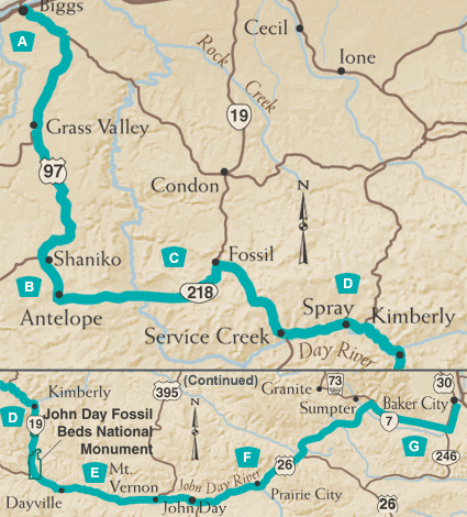
The Journey Through Time Scenic Byway stretches 286 miles through north central to eastern Oregon. Beginning in the community of Biggs and ending in Baker City, this Byway meanders through ghost towns and small farming communities that bring the Old West to life. The Wild and Scenic John Day River - North America's second longest undammed river - parallels much of the route, offering excellent rafting, fishing and camping. Geology buffs — and anyone who's curious about fossils — will take great pleasure in the interpretive trails at the John Day Fossil Beds. Historic commemorations of more recent times, such as the Sherman County Museum in Moro, the Kam Wah Chung Museum in John Day, the gold mining remnants in Sumpter and the Oregon Trail Interpretive Center near Baker City offer telling windows into Oregon pioneer life.
A. Leaving the Columbia
Your Journey Through Time begins in the town of Biggs, 17 miles east of The Dalles on I-84. You'll move south from Native American salmon-harvesting spots on the Columbia toward Wasco, site of the original Columbia Southern Railway depot which still stands and dates back to 1898. Be sure to visit the Sherman County Historical Museum in Moro. The museum includes over 15,000 artifacts and exhibits on Native American life, Oregon Trail—migration, rural living, and wheat farming.
B. Shaniko to Antelope
With Mount Hood and Mount Jefferson looming in the west, you'll reach Shaniko — the Wool Shipping Center of the World in the 1880s, and now a "living" ghost town. The recently renovated Shaniko Hotel is open for business, and listed on the National Register of Historic places. From here, take Route 218 to Antelope. The hills of this region provide habitat for the town's prong-horned namesake, and were the site of Rajneeshpuram, a religious community that briefly flourished and disbanded in the early 1980s.
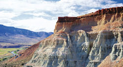
C. Fossil and Fossils
East of Antelope, you'll come to the Clarno Unit of the John Day Fossil Beds National Monument. The three units of the Monument comprise a well-preserved fossil record of plants and animals dating back 6 to 54 million years - The Cenozoic Era, or Age of Mammals and Flowering Plants. The Clarno Unit consists primarily of hardened mudflows or lahars, which captured fossilized plants and animals in their wake. Visitors can walk several interpretive trails. Eighteen miles farther east, you'll come upon the town of Fossil, established in the 1880s - and named for a fossilized mammoth bone found in the vicinity. Fossil offers amateur archeologists a chance to do some free prospecting for leaf imprints at the public fossil-collecting site in town. A few motels and restaurants are available.
D. Service Creek to Kimberly
 Heading
south from Fossil, the Journey Through Time Scenic Byway joins the Wild
and Scenic John Day River at Service Creek, an old stagecoach stop; the
river skirts the Byway for the next 100 miles. Next, you'll reach Spray,
site of a key turn-of-the-century ferry crossing that allowed travelers
to reach The Dalles Military Road farther west. The North Fork of the
John Day joins the mainstem of the river at Kimberley, which is known
for its bountiful orchards of cherries, apricots, peaches, nectarines,
apples and pears.
Heading
south from Fossil, the Journey Through Time Scenic Byway joins the Wild
and Scenic John Day River at Service Creek, an old stagecoach stop; the
river skirts the Byway for the next 100 miles. Next, you'll reach Spray,
site of a key turn-of-the-century ferry crossing that allowed travelers
to reach The Dalles Military Road farther west. The North Fork of the
John Day joins the mainstem of the river at Kimberley, which is known
for its bountiful orchards of cherries, apricots, peaches, nectarines,
apples and pears.
Cant Ranch National Historic District, across the highway from the Thomas Condon Visitor Center (currently under construction) , features displays of old farm equipment plus descriptions of sheep and cattle ranching in the early 1900s.
E. Kimberley to John Day
The stretch of Highway 19 from Kimberley to Dayville showcases the beauty of the John Day Canyon. Rimrock flanks the roadway, and the river winds below while raptors glide in the thermals overhead. Several interpretive hikes are easily accessed from the Byway, including the Foree Trailhead, which features basalt flows dated at 16 million years, and Blue Basin, which includes casts of turtle and saber-toothed cat fossils harvested from the site. Two noteworthy formations, Cathedral Rock and Mascall Overlook, can be viewed from the road. The John Day National Monument's main headquarters is located at the Visitor Center at the Sheep Rock Unit. Passing through rich cattle country, you'll soon reach John Day, the largest town along the route. John Day is famous for the annual cattle drive that goes through town. It's also home to the Kam Wah Chung Museum, which honors the culture of the Chinese railroad workers and miners who settled here in the 1880s.
F. Strawberries and Blues
 Pushing
east from John Day you soon reach Prairie City, home of the DeWit Depot
Museum, listed on the National Register of Historic Places. Strawberry
Mountain overlooks the town, creating one of the most photogenic vistas
on this Byway. The Byway now heads in a northeasterly direction on Oregon
Route 7, leaving the John Day River and climbing through the foothills
of the Blue Mountains. On a clear day, it seems you can see forever. You'll
pass through Whitney, one of Oregon's more accessible ghost towns, and
then reach Sumpter.
Pushing
east from John Day you soon reach Prairie City, home of the DeWit Depot
Museum, listed on the National Register of Historic Places. Strawberry
Mountain overlooks the town, creating one of the most photogenic vistas
on this Byway. The Byway now heads in a northeasterly direction on Oregon
Route 7, leaving the John Day River and climbing through the foothills
of the Blue Mountains. On a clear day, it seems you can see forever. You'll
pass through Whitney, one of Oregon's more accessible ghost towns, and
then reach Sumpter.
G. Sumpter to Baker City
Sumpter was a major gold mining center in Eastern Oregon. Gold was extracted from the valleys of the Blue Mountains with a 1,240-ton dredge. Long piles of gravel tailings are still visible along the Byway, and the dredge has been restored. Train buffs will want to visit the original narrow gauge steam train of the renamed Sumpter Valley Railway. The train runs Memorial Day through September. East of Sumpter, the Journey Through Time Scenic Byway joins the Elkhorn Drive Scenic Byway and offers breathtaking vistas of the Blue Mountains and Elkhorn Range. You'll make a gradual descent to Baker City, with its historic downtown. Just east of Baker City is the National Historic Oregon Trail Interpretive Center.